5 Best Drones for Environmental Monitoring in India

By Saheel Singh
| 26 Aug 2025
Drones are part of many applications and industries of late, and it would not be incorrect to say that they are a part of the technological transformation going on in the world. Environment and wildlife monitoring is one such application that drones have become a part of. Previously, this application involved humans surveying various environments and noticing what was happening, which is out of the ordinary. This even put the lives of surveyors at risk, and the entire survey took a lot of time.
Now, with the advent of drones, there is no need for humans to go to dangerous or even life-threatening locations. They can just manoeuvre the drones from a safe vicinity, and the drones will do the job. Modern drones are laden with advanced cameras and sensors, which help the drones do the job with the speed and accuracy for which they are meant.
Not all drones serve the same purpose, but there are different drones that do different things. Some are masters at photography and videography; some are intended to prove their worth in agricultural practices, some work fine for land surveys, and some are specially made for the purpose of environmental and wildlife monitoring.
Here, we will look at the top 5 drones for environmental monitoring in India.
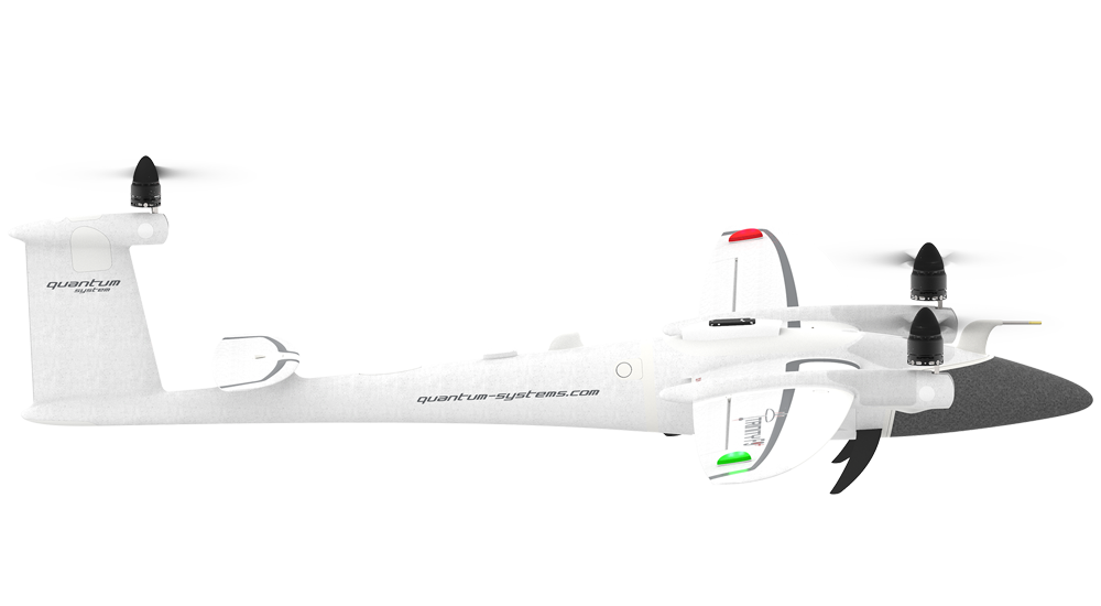
Quantum Systems Trinity F90+
roThis is a fixed-wing drone which is able to provide endurance and proficiency. Its excellent cameras make it a fine equipment for important environmental monitoring projects.
What Makes it Worth Choosing?
• It can stay in the air for as long as 90 minutes in a single charge.
• This holds a potential to survey an area of 400-500 sq. km without needing to come to ground. This is the reason it proves its worth in expansive studies
• There are cutting-edge multispectral cameras for monitoring the health of plants, analysis of the crops, and biodiversity studies.
• GPS and RTK Integration in this drone ensures georeferencing and precision mapping.
• This drone is fairly easy to use and is just perfect for getting deployed in remote regions.
• This drone can prove its worth in various applications such as wildlife monitoring, deforestation, agricultural land management, biodiversity studies, floodplain analysis, and climate studies.
This drone camera holds forth in being sturdy precision mapping, and payload versatility, providing researchers a lasting and consistent monitoring solution.

SkyFi Fixed-Wing Drone
This advanced drone is a fine option for extensive mapping and long flight. With an ability to stay in the aur for long and offering accurate mapping results, it can cover vast environmental lands in a single charge.
What Makes it Worth Choosing?
• Its capability to stay in the air for about 100 minutes makes it a it a force to reckon with for long-range surveys.
• With impressive flight time, this drone also does not hold back in the coverage capabilities, thus improving the efficiency of collecting data.
• There are thermal imaging and multispectral cameras for analyzing the environment efficiently.
• The drone has a feature of RTK Precision, which makes sure that the data collected is accurate, highly accurate and suitable for environmental research.
• This drone can be used for checking the health of the forests, agricultural fields, water resource mapping and urban planning.
Owing to its long-range, versatility, and advanced technology for environmental scientists conducting lasting monitoring.

Parrot Disco Fixed-Wing Drone
This is another fixed-wing drone, which is known for its effectiveness and ease of use. With its emphasis on ease of use and adaptability, it’s a must have for relatively smaller environmental monitoring projects.
What makes it Worth Choosing?
• This drone has a total flight time of 45 minutes for wide-area monitoring.
• There are multispectral cameras fixed in this drone, making it a good choice for environmental analysis.
• This drone has rather simple controls and incorporation into field operations.
• If you are to do urban heat mapping, wildlife surveys, agricultural research and forest conservation, this drone can serve the purpose well and truly.
What makes Parrot Disco different from the other environmental monitoring drones is its ability to provide greater flexibility for environmental researchers and that too without costing much.

Alti Transition Drone
Talking of this drone, it comes under the hybrid category offering a mix of multirotor and fixed-wing drone. It is especially optimized for diverse monitoring projects. Its adaptability lets it to combine endurance with the flexibility of multirotor flight.
What Makes it Worth Choosing?
• Its hybrid design is a mix of agility of multirotor drone and endurance of fixed-wing drones.
• The total time for which it can stay in the air is 180 minutes
• This drone has got it all, what is needed for environmental monitoring, be it thermal imaging, multispectral and high-resolution cameras.
• This drone can come good for water resource mapping, forest health surveys, flood risk analysis, and climate change research.
It is a versatile choice for adaptive ecologists and researchers for carrying out projects of environmental monitoring.

SenseFly eBee SQ
This fixed-wing drone is intended for providing accurate environmental mapping and analyzing the agricultural fields. Its operational ease and wide-area mapping competences make it a topmost choice for environmental studies.
What Makes it Worth Choosing?
• On a single charge, this drone can stay in the air for 60-90 minutes
• This comes with the potential to survey hundreds of sq. km without coming to ground for battery swapping or recharging
• This drone is well-equipped with thermal imaging cameras, multispectral cameras and photogrammetry tools.
• The integration of RTK GPS makes it a high-precision environmental mapping.
• This drone can help you with forest surveys, wildlife monitoring, flood analysis, and tracking the health of plants.
It is a good option, when it comes to extensive monitoring, mostly in India’s extensive agricultural regions.
Final Few Words
These are some of the finest drones for environmental monitoring in India because of their features. For making the best use of the same for conducting surveys, there is a need to be proficient in drone piloting and also possess a license. Come to us at Flapone Aviation and learn drone piloting from the very basic to the advanced levels and make a living out of it.
BLOG
Related Blog
Latest updates and insights from Flapone Aviation.


What Types of Drones Are Present in the Market?
July 11, 2025

How to Become a Pilot After 12th in India?
August 26, 2025
What are the Basics of Drone Piloting?
August 26, 2025
Author Bio
A dynamic and seasoned content writer with 6 years of experience curating content for different platforms. With the knowledge of all the cogs of content writing and SEO, he has served in various industries. He believes that content is the kingpin, and if penned well, it has a lasting impact on the minds of the readers. Apart from content creation, he is also an ardent poetry lover and performer. He has two publications of his poetry collection, namely Alfaaz and Chestha